poor, abandoned blog
life's been crazy and ebay blows. that's my explanation.
There’s an unmistakable perfume that permeates Portland air in the summer months. The dreary gray days have receded (mostly) into a winter memory and slow, sun baked lushness finally blossoms in all its glory. A verdant, fragrant, gorgeous city enjoys itself and the quality of life it offers it inhabitants.  I had the opportunity to revisit this often overlooked gem in the pacific northwest last weekend that cradled me through college and its aftermath. A sizeable part of me wants it to remain overlooked, although judging by the Pearl District, north/NE Portland, and SE, I think that notion can be tossed out the window.
Besides attending an ideal summer wedding (congratulations Maria and Jason), checking out my brother’s james bondesque lab at nike, strolling through Saturday Market on the Willamette River, and eating at the greatest breakfast café ever, we managed to make our way up to Mount St. Helens for a quick outing. More than ever, I stood agape taking my first glimpse of the mammoth crater carved from the 1980 eruption. Even at a distance of 5 miles (access to the mountain has been severely limited due to the recent spate of volcanic/seismic activity) the sight is humbling.
I learned some stuff: At 8:31 on May 18, 1980, Mount St. Helens in southwest Washington State stood at 9,677 feet above sea level, minutes later 1,314 vertical feet lay scattered across the surrounding countryside or hovering miles above. The mountain now stood at 8,363 feet above sea level. A yawning crater facing the north (1.2 miles east-west, 1.8 miles north-south, 2,084 feet deep) offered the beautiful peak that had stood there before. (I took this pic looking southward at the i-got-my-shit-kicked north part of the mountain, check out the steaming vent)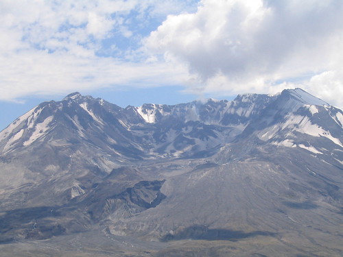
After months of warning activity that included repeated earthquakes, a steaming crater, and a bulging north flank, the anticipated climax arrived on the morning of May 18, 1980 (I had 15 days to prepare for the party upon entering this world). Perhaps causing, but more likely caused by a 5.1 magnitude earthquake 1 mile beneath the volcano, three successive landslides ripped away the north flank of the mountain. Picking up rocks and trees during its violent descent, this landslide transformed into a jumbled debris avalanche that eventually covered 23 square miles, buried the North Fork Toutle River to an average depth of 150 feet, and reached velocities up to 150 mph. this avalanche swept over towering ridges (which I hiked across this weekend, and never in my life would have imagined could have been overrun) and completely buried pristine Spirit Lake and good old Harry Truman (although there's some debate regarding whether the ensuing explosion reached him first). Before literally swallowing the water in Spirit Lake, the landslide ‘pushed’ it toward its northern shore and forced a flood of water up an 800 foot embankment on the other end before the water came crashing back to the now covered lake floor. If Harry was gonna go out, I think he did it in style.
The disappearance of the north flank relieved restricting pressure on the yearning gas deep within the bowels of the volcano. This superheated gas expanded at hugely accelerated rates and blasted through the weakened walls of the north flank. This fiery explosion was enhanced by vaporized snow and ice which, when mixed with ash and lava, formed a dramatic steam column rising an estimated 16 vertical miles above the crater. At its most violent, the blast tore away from the mountain at 300 mph. 300 mph!!! The blast was so strong and toxic that 4 billion board feet of timber (enough to build about 300,000 2-bedroom homes) blew down in the face of such pressure. You can still see many of the toppled trees to this day all lying with their tips facing northward, some with diameters as large as 8 feet. This ash column followed the prevailing winds and spread eastward across the state, the nation, and eventually encircled the entire globe 15 days later! My family in eastern Washington holds distinct memories of having to shovel an inch of volcanic ash off cars and sidewalks some 200 miles away.
All this heat melted glacier ice and snow and sent it cascading down the side of the mountain. As it sunk into the ground, a dangerous slurry of cement-like mud raged down the mountain, carrying trees and boulders along. This thick paste clogged rivers and punished any bridge or home in its path. Between this and the accompanying pyroclastic flows, any untouched forest or river in the path of the eruption eventually met its doom. For some great pictures of before, during, and after the explosion, check out this site. If you have a slow computer be prepared to wait while it loads because all the pictures reside on the same page.
Aside from the 57 people who lost their lives due to the eruption, wildlife perished in droves. The Washington State Department of Game estimates that 7,000 big game animals died, along with all birds and most small mammals. Furthermore, the Department of fisheries estimated that 12 million Chinook and Coho salmon fingerlings were killed when hatcheries were destroyed. Another estimated 40,000 young salmon were lost when forced to swim through turbine blades of hydroelectric generators as reservoir levels along the Lewis River were kept low to accommodate possible mudflows and flooding.
Staring at Mount St. Helens reminded me that mother nature remains the most awesome and devastating force on this planet as evidenced recently by the 1991 Bangladesh floods, the 2003 Iran earthquake, and the 2004 Tsunami in the Indian Ocean. Compared to these natural disasters of immense proportions, in human terms the 1980 Mt. St. Helens earthquake proves but a tiny dot on the radar screen. Its location in the United States surely catapulted its importance in the eyes of national and international press, perhaps beyond its due limit. However, just as the Grand Canyon is one of those natural scenic points that simply blows you away regardless of how much you’ve heard before visiting, so too does Mt. St. Helens make your jaw scrape along the gravel trail when you consider how much force it required to transplant that much earth in a geological instant. If a city had surrounded the base of the mountain, it would have been completely annihilated. Don't laugh. in fact, move up the Cascade Range to next prominent peak: Mt. Rainier. should this 14,000 foot giant realize its all too real volcanic potential, the Seattle-Tacoma area, especially the south-eastern satellite communities, might suffer catastrophic fatalities, not to mention the economic blow. Consider San Francisco or any number of metropolitan areas along the California coast that sit prostrate as the earth's crust amasses pressure, just waiting to unleash an earthquake of mammoth proportions, with the possibility of an ensuing tsunami. These are just a couple examples from one region in one corner of the globe.
I'm sayin'...I'm just sayin'.

2 comments:
Glad I'm not the only one thinkin about stuff like this. Though I joked about it in a recent post, I really have given it a lot of thought. If mother nature decides to crack off another large one around here, and it happened to be a it off the coast here the entire area would be left in ruins by a tsunami. Granted, we're a little more prepared than we were in 89 as far as retrofitting and such, so that's a little comforting.
just another day in paradise. i'm pretty sure the whole west coast is toast-cheese pretty soon here. red state retribution. speaking of which,check out this crazy site. and no, i didn't have to consult a map to see how the west coast voted.
Post a Comment