Drawing an important, but difficult line
One of the projects I’m participating in at the National Academies seeks to determine the extent of Ecosystem impact due to fishing and make recommendations about halting or reversing the damage. This has proven an interesting and complicated topic for a number of reasons.
For one thing, the volume of our global oceans dwarfs any scale we typically discuss, which makes it incredibly difficult to gather the requisite data. The five oceans (yes, 5…in 2000 the International Hydrographic Organization denoted the Southern Ocean which surrounds Antarctica and extends to 60 degrees latitude) cover 70% of the earth’s surface and dive to depths of over 36,000 feet. That’s an unimaginably vast region to monitor. Although satellites, an international fleet of research vessels, and unmanned buoys distributed in all corners of the globe constantly process information, it’s not even close to enough.
Then there’s the problem with data we do collect. Available information focuses on a few lucrative target species that can be gauged relatively accurately. Although this data seems mostly reliable, the preponderance of the information comes from the fisheries themselves, which presents the possibility of bias (although fisheries argue somewhat convincingly that they have an invested interest in maintaining a robust stock more than anyone, hence, why would they distort numbers to increase fish abundance). Regardless, these condition of these key fish stocks are known pretty well.
The impact on subspecies, non-target peripheral species, and non-fish marine life remains largely unknown, however. This occurs in a couple ways. For instance, the enormous nets used by commercial and industrial fisheries aren’t selective about which species they sweep up. Therefore, although a trawler in Northern California might only gather fish in an area known for high rockfish concentration, that doesn’t mean the rockfish will always swim there and it doesn’t mean the rockfish will exclusively swim there. Inevitably, many undesired lifeforms meet their demise in a confused tangle of net. Some choke themselves or slit their own throats on the netting, others are eaten in the melee, still others manage to escape but leave behind a crucial fin or an eye, thus leaving them prostrate to the brutal Darwinian forces operating in the seas. Those that don’t die on the boat are thrown back in an often mortally weakened state that basically guaruntees their imminent end. All these species perish to nobody’s benefit and most of them are not accounted for.
Beyond that, although the fish might escape the net, their habitat might not. Imperiled coral reefs, mangrove forests, and sediment beds constitute just a fraction of the habitat damage inflicted by these nets. Do you really think the fish will survive without that vital protection?
Then, there’s the clutter left behind: oil, nets, boats, ropes, pulleys, aluminum cans, drums, etc. etc.
Now, consider the cascading effect of severely diminishing one top-tier predator from the oceans. Blue marlin and swordfish, for example, once thrived in the central north Pacific, but their numbers plummeted in the second half of the 20th century. This allowed the small tuna population, the prey of those larger predators, to thrive. If given sunlight, the grass will grow. Or perhaps a fish species disappears the fed off the microscopic life at the ocean’s surface. Algae thrives, maybe to the point of taking over vast areas.
So does this constitute ‘damage’ to the ocean’s ecosystem, or is this just humans playing their role in evolution and natural selection. Sure, we kill off one species, but that means something else thrives. How do we decide if we should stop or even reverse an ecosystem (given the dubious argument that it is possible) and if so, to what former point on the temporal scale will be determine the pristine, wilderness ocean? If we do condone human invasion of the seas to gather nourishment where do we establish the cut-off point for such intervention and manipulation?
I don’t count myself among those promoting a complete withdrawal from the seas. I’ve fished before and I will happily fish again. My personal philosophy is that humans are another type of animal that uses primarily intellectual and technical ingenuity to subsist, rather than physical ability. Either way, we still need to consume to survive, just like any other animal. In reality, the gigantic net is only an extension of the spear. The exception, of course, being that the spear doesn’t kill things it doesn’t intend to kill. I think if you fish, then you should eat what you catch. I’d say the same about hunting. Therefore, I look forward to the advent of techniques that allow targeted fish, and only targeted fish, to be caught in humane ways.
By diversifying our diets and avoiding unnecessary and inhumane kills, I think we can move closer to impacting the ecosystem less while remaining realistic about the fact that we are member-crucial members-of this global community and will invariably leave our mark. We adjust to what we know, and if more types of cuisine passed down our throat, we’d realize there’s no reason to concentrate on just a few. This ensures that no species diminishes to the point of extinction. The important thing is that the consumer ultimately drives the market. If you disagree with the harvesting of a particular type of species, don’t eat it. If you think others should do the same, offer a convincing argument defending your position. Screaming at somebody won’t do the trick.
Lest this entry turn into a novel and cheap proselytizing, somebody put a muzzle on me. I’m running away to the wilds of Virginia for the weekend, so fare ye well. (ps. i wrote this kinda fast and gotta cruise so i apologize for any glaring grammatical mistakes, missed words, etc....also, as always, i apologize for myself in general)
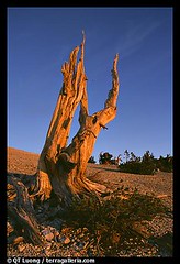 It seems the Bristlecone Pine has managed to stave off competition hungry to enforce the Darwinian call for newer, stronger species by employing a number of self-protection techniques. Thriving at typical elevations between 10,000 and 11,000 feet, Bristlecones persist in circumstances other types of growth find uninhabitable. They survive on dolomite and alkaline soil layers that offer insufficient nutrients for most types of growth. Furthermore, they know how to protect themselves from each other. Loners for life, these ancient trees leave ample room between themselves, thus ensuring that lightening strikes normally only destroy small clumps of trees, instead of whole forests. Fire cannot jump the distance between trees and no ground cover serves to transfer the flames. Also, if damaged by fire, drought or storms, much of the bark and tissue that conducts water dies back, effectively reducing the nutrient load the tree must supply to tissue and balancing the result of the damage. It seems you learn a lesson or two over the course of millennia.
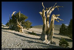 Mommy and daddy Bristlecone conceived the oldest known individual tree in the world, Methuselah, 4,789 years ago (it celebrated its 100th birthday when the Egyptian Pyramids were being contructed). Methuselah traveled much in its younger years but returned to the White Mountains of California to live its millennia out among relatives. Methuselah descended into a severe depression in 1964 after the US Forest Service allowed a geologist to cut down his older brother Prometheus. The geologist’s coring tool broke after passing 4,000 years and USFS decided finding out that Prometheus was 4,950 years old was more important than letting it live. USFS now strictly protects these venerable soldiers.
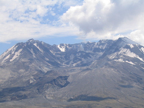
 I had the opportunity to revisit this often overlooked gem in the pacific northwest last weekend that cradled me through college and its aftermath. A sizeable part of me wants it to remain overlooked, although judging by the Pearl District, north/NE Portland, and SE, I think that notion can be tossed out the window.